Research Scope
Domain & technical foundation
ASICOP covers quota-based irrigation operations where reservoir storage, canal flows, satellite crop stress, weather risk, and seasonal economics shape a unified decision loop.
Literature Survey
Why this domain matters
Smart irrigation is not only a sensor problem. In a canal-command area, every field decision must respect reservoir storage, canal releases, weather risk, crop stress, market value, and authority-level water policy.
Sri Lankan irrigation schemes such as Udawalawe manage water through reservoir releases, branch canals, seasonal quotas, and farmer-level field decisions. A useful platform must therefore connect field demand with scheme-level storage and release planning.
IoT soil and water-level sensing improves visibility inside fields, but isolated controllers cannot decide safely unless they also know forecasted rainfall, crop stress severity, reservoir safety limits, and quota availability.
Remote sensing research shows that Sentinel-2 vegetation indices such as NDVI and NDWI can surface crop water stress at zone level, while plant-image transfer learning can provide disease-specific recommendations when a farmer uploads a field photo.
Forecasting and optimization research can support release planning and crop-area allocation, but most prototypes treat these as separate systems. This project studies them as one operating loop where forecast risk and crop stress alter irrigation and crop plans.
Research gap
Existing systems usually optimize only one layer: IoT valve control, crop stress detection, reservoir forecasting, or crop planning. The gap is an integrated decision platform where those signals change one another before the farmer or officer acts.
Research problem
How can IoT telemetry, crop health analytics, water forecasting, and crop-area optimization be integrated to reduce water waste and improve crop planning under fixed irrigation quotas in Sri Lankan schemes?
Domain-specific scope
Four domain layers behind the platform
The project scope combines agricultural, hydrological, remote-sensing, and economic context from the documented research material.
Irrigation command-area operations
The project is grounded in canal-based irrigation, where reservoir level, active storage, inflow, rainfall, spillway discharge, and LB/RB main canal releases shape how much water can be issued to fields.
Field water stress and crop health
The crop-health stream treats water stress as a spatial signal. NDVI measures vegetation vigor, NDWI reflects canopy water content, and a stress index converts zone results into field-level priority.
Reservoir risk under monsoon uncertainty
The forecasting stream focuses on short-horizon reservoir behavior in Sri Lanka's seasonal rainfall context, where dry spells, sudden inflows, and human release timing all matter.
Crop economics and seasonal allocation
The optimization stream connects agronomic suitability with volatile Sri Lankan retail prices, seasonal Maha/Yala context, water quota, and minimum paddy allocation policies.
Objectives
Main & specific objectives
The main objective is to design, implement, and validate an integrated smart irrigation and crop optimization platform for water-constrained agriculture.
Automate irrigation decisions
Use ESP32 telemetry, crop threshold tables, a Random Forest valve classifier, and reservoir release prediction to recommend OPEN, CLOSE, or HOLD actions for each field.
Detect crop health and water stress
Combine Sentinel-2 NDVI/NDWI zone analysis with MobileNetV2 image prediction to classify field stress, disease severity, and treatment recommendations.
Forecast rainfall and reservoir risk
Generate 1-14 day water-level and rainfall forecasts, P10/P50/P90 risk bands, and anomaly alerts for drought, flood, and canal demand pressure.
Optimize crop area under quota
Use Fuzzy-TOPSIS, market price prediction, yield assumptions, and constrained allocation to recommend crop mixes that respect soil, water, profit, and paddy policy rules.
Methodology & System Architecture
From domain research to integrated prototype
Our methodology follows a clean research-to-system path: define the water-management problem, engineer stream-specific datasets, train suitable ML models, and integrate their outputs through service contracts and decision rules.
Interactive Platform Microservice Architecture
Research & Implementation Phases
Domain study and research gap
The work begins with the operating reality of Udawalawe-style irrigation: water is issued through reservoirs and canals, farmers need plot-level decisions, and authorities must keep within scheme-level quotas.
Data acquisition and cleaning
Each stream builds its own evidence base: hydrological Excel sheets for release prediction, Sentinel-2 and PlantVillage data for crop health, reservoir time series for forecasting, and price/climate datasets for optimization.
Feature engineering and modelling
The models use domain-shaped features rather than generic inputs: lagged canal releases, rolling rainfall, NDVI/NDWI thresholds, monsoon encodings, price lags, and water-stress constraints.
Decision logic and integration
Model predictions are converted into actions using service rules. F1 gates valve decisions with reservoir limits, F2 converts stress into priority, F3 turns uncertainty into water scenarios, and F4 turns those signals into crop-area recommendations.
Evaluation and honest limitation tracking
The project records both strong results and current weaknesses, including synthetic irrigation labels, proxy satellite stress labels, F3's single-sheet notebook limitation, and F4's price-data mismatch.
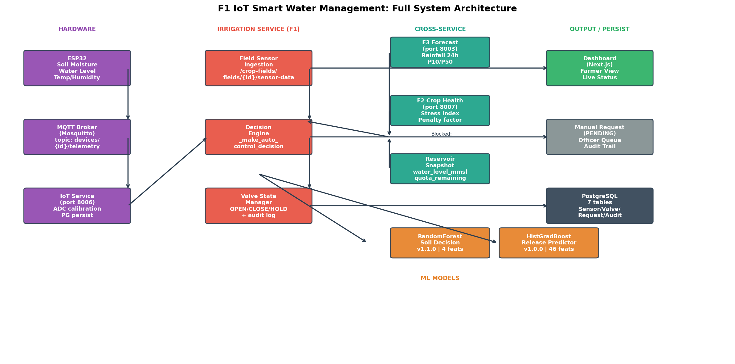
Detailed System Topology
Research stream detail
What each module actually contributes
Each stream owns a different domain problem, dataset, model family, evaluation result, and integration contract inside the full platform.
F1 - IoT Smart Water Management
Reservoir-to-field irrigation control
Dataset:Udawalawe Hydrological Data, 32 year-sheets from 1994-2025, 11,687 daily records and 10,945 model-ready rows after target cleaning.
Method:A HistGradientBoostingRegressor predicts next-day combined canal release from 46 engineered hydrological features, while a RandomForestClassifier recommends field valve actions from soil moisture, temperature, humidity, and time of day.
Evaluation:The selected release model achieved MAE 0.4412 MCM, RMSE 0.7108 MCM, and R2 0.7949 on the 2023-2025 time-based test set.
Integration:F1 consumes rainfall forecasts from F3 and crop stress priority from F2, then blocks or escalates valve actions using reservoir level, quota, and manual approval rules.
F2 - Crop Health and Water Stress
Remote sensing, crop disease, and field stress priority
Dataset:Sentinel-2 Level-2A imagery over Udawalawe at 10 m scale, plus PlantVillage crop-image data for 38 disease and healthy classes.
Method:Track A computes NDVI and NDWI, applies vegetation validation, and classifies zone stress with Random Forest. Track B uses MobileNetV2 transfer learning for uploaded crop-image diagnosis.
Evaluation:The satellite Random Forest reaches about 99% accuracy on NDVI/NDWI-derived labels, and MobileNetV2 reaches 95.43% best validation accuracy after 10 epochs.
Integration:A field-level stress index maps mild and severe zone ratios into low, medium, high, or critical priority for F1 and a penalty factor for F4 suitability scoring.
F3 - ML Time-Series Forecasting and Alerting
Reservoir water-level forecasting and risk bands
Dataset:The forecasting notebook references the same 1994-2025 Udawalawe workbook, but the current notebook loads only the first 1994 sheet, producing 358 cleaned rows.
Method:Experiments include Random Forest, Gradient Boosting, LSTM, and quantile regressors; the service architecture adds Linear Regression, ARIMA/SARIMA, ensemble forecasting, and anomaly detection.
Evaluation:On the limited 1994 subset, Gradient Boosting is the best notebook model with RMSE 2.8763 mMSL and MAE 2.7027 mMSL, while negative R2 values are documented as a dataset loading limitation.
Integration:F3 provides 1-14 day forecasts, weather intelligence, and P10/P50/P90 water scenarios to suppress unnecessary irrigation and constrain optimization under conservative water availability.
F4 - Adaptive Crop and Area Optimization
Crop suitability, market risk, and constrained area planning
Dataset:The optimization stream uses 71,737 Hector retail price observations, 314,000 climate records, 1,039 paddy cultivation records, and a 324-row rice time series baseline.
Method:Fuzzy-TOPSIS ranks crop suitability across soil, water coverage, yield, water sensitivity, and growth duration; price models and allocation logic then estimate profit and assign hectares under constraints.
Evaluation:The price neural model reports MAE Rs. 115.66/kg and RMSE Rs. 175.81/kg; 5-fold validation remains stable, while the crop recommender is treated as a market signal rather than full agronomic truth.
Integration:F4 pulls water availability from F1, stress penalties from F2, and P10/P50/P90 forecast scenarios from F3 before returning Top-3 crop plans, water budget use, risk level, and Plan B options.
Evidence and metrics
Research results kept visible
The site presents results from the documented notebooks and service research, including limitations where the evidence is still maturing.
F1 - Release prediction
RMSE 0.7108 MCM
HistGradientBoosting on 2023-2025 test data from the 32-sheet Udawalawe workbook.
F2 - Disease classification
95.43% val accuracy
MobileNetV2 transfer learning across 38 PlantVillage crop health classes.
F3 - Best current forecast
RMSE 2.8763 mMSL
Gradient Boosting on the limited 1994 notebook subset; full multi-year training is documented as the fix.
F4 - Price prediction
MAE Rs. 115.66/kg
PricePredictorNN result on Hector-derived crop price data, used as a relative market signal.
Cross-service loop
How one stream changes another
The core research contribution is the integration layer. Predictions become operational signals that affect irrigation, crop ranking, water budgeting, and mid-season Plan B decisions.
High or critical stress can elevate an OPEN request and increase officer attention.
Forecasted rain can reduce valve position or suppress unnecessary watering.
The optimizer uses live water availability as a hard constraint for crop-area allocation.
Crop plans can be evaluated under conservative, expected, and optimistic water conditions.
Stressed fields receive reduced effective suitability before crop ranking.
Technologies used
A production-style research stack
The implementation combines web engineering, IoT communication, geospatial analysis, machine learning, optimization, and deployment infrastructure.
Backend services and APIs
Independent microservices expose typed REST contracts for irrigation, crop health, forecasting, optimization, auth, IoT, and gateway routing.
Data, telemetry, and messaging
Operational readings, recommendations, event streams, and cached service context are stored or exchanged through the shared platform layer.
Machine learning and optimization
Each stream uses the model family that fits its domain: tree models for tabular hydrology, CNN transfer learning for images, statistical forecasting for time series, and optimization for crop planning.
Frontend and infrastructure
The website and dashboard are backed by typed frontend routes and deployment assets that support repeatable demonstrations.
Remote sensing and climate sources
The domain layer depends on agricultural and hydrological evidence from satellite imagery, public weather APIs, and Sri Lankan operational datasets.
IoT and control layer
Field hardware and control rules keep the research connected to real irrigation actions rather than only analytical dashboards.
Limitations & future work
A transparent research roadmap
The project documents where the current prototype is strong, and where additional field evidence, data cleaning, or solver maturity is still required.
Replace F1 synthetic valve labels with real Udawalawe sensor and actuator logs from field trials.
Validate F2 satellite stress labels using agronomist or field-survey ground truth instead of only NDVI/NDWI proxy rules.
Fix F3 multi-sheet loading so the forecasting notebook trains on the full 1994-2025 workbook rather than only 1994.
Move F4 allocation from the active greedy heuristic to the documented PuLP linear programming solver for larger multi-field planning.
Recalibrate thresholds, Fuzzy-TOPSIS weights, reservoir gates, and crop calendars before applying the platform to irrigation schemes outside Udawalawe.
Service ownership
API gateway service routing ports
irrigation_service
F1 Irrigation
Field telemetry, crop thresholds, reservoir safety gates, and ML predictions are fused into valve actions for quota-based irrigation fields.
crop_health_and_water_stress_detection
F2 Crop Health
Remote-sensing zone health and plant image diagnosis identify stress early enough to prioritize irrigation and adjust crop planning.
forecasting_service
F3 Forecasting
Reservoir and rainfall forecasts expose drought, flood, and uncertainty signals before they affect field schedules or seasonal plans.
optimize_service
F4 ACA-O
Crop suitability, price signals, water quotas, field stress, and policy rules are combined into practical crop-area recommendations.